
OET OET-RV OET-LV GHT ULT UST BSB MSB BLB AICNT OEB WEBBE WMBB NET LSV FBV TCNT T4T LEB BBE Moff JPS Wymth ASV DRA YLT Drby RV SLT Wbstr KJB-1769 KJB-1611 Bshps Gnva Cvdl TNT Wycl SR-GNT UHB BrLXX BrTr Related Parallel Simple Interlinear Topics Reference Dictionary Search
OET By Document By Section By Chapter Details
OET INT FRT GEN EXO LEV NUM DEU JOB JOS JDG RUTH 1 SAM 2 SAM PSA AMOS HOS 1 KI 2 KI 1 CHR 2 CHR PROV ECC SNG JOEL MIC ISA ZEP HAB JER LAM YNA NAH OBA DAN EZE EZRA EST NEH HAG ZEC MAL GES LES ESG DNG 2 PS TOB JDT WIS SIR BAR MAN 1 MAC 2 MAC 3 MAC 4 MAC YHN MARK MAT LUKE ACTs YAC GAL 1 TH 2 TH 1 COR 2 COR ROM COL PHM EPH PHP 1 TIM TIT 1 PET 2 PET 2 TIM HEB YUD 1 YHN 2 YHN 3 YHN REV
EXO Intro C1 C2 C3 C4 C5 C6 C7 C8 C9 C10 C11 C12 C13 C14 C15 C16 C17 C18 C19 C20 C21 C22 C23 C24 C25 C26 C27 C28 C29 C30 C31 C32 C33 C34 C35 C36 C37 C38 C39 C40
This is still an early look into the drafted text of the Open English Translation of the Bible. Please double-check the text in advance before using in public.
17:8 Mosheh’s arms held high to defeat Amalek
8 Then the Amalek army came and attacked Yisrael at Refidim, 9 and Mosheh instructed Yehoshua (Joshua), “Choose men for us and go out and fight with Amalek. Tomorrow I’ll be stationed on top of the hill with the staff of God in my hand.” 10 So Yehoshua prepared to fight Amalek as Mosheh had told him, and Mosheh, Aharon, and Hur climbed up to the top of the hill. 11 And so it happened that when Mosheh raised his arm, then Yisrael would be winning, but when he lowered his arm, then Amalek would start winning. 12 However, Mosheh’s arms got tired, so they got a large stone and sat him on it, and Aharon and Hur stood on each side of him holding up his arms, and holding him steady in that position until the sun went down. 13 So this was how Yehoshua defeated Amalek and his army with their swords. 14 Then Yahweh told Mosheh, “Write this event in the book and read it aloud to Yehoshua, because I will certainly blot out the memory of Amalek from off the earth.”[ref] 15 Then Mosheh built an altar and he named it ‘Yahweh-nissi’ (which means ‘Yahweh is my banner’), 16 saying, “Because they battled against Yah’s throne, then Yahweh will battle against Amalek throughout the generations.”

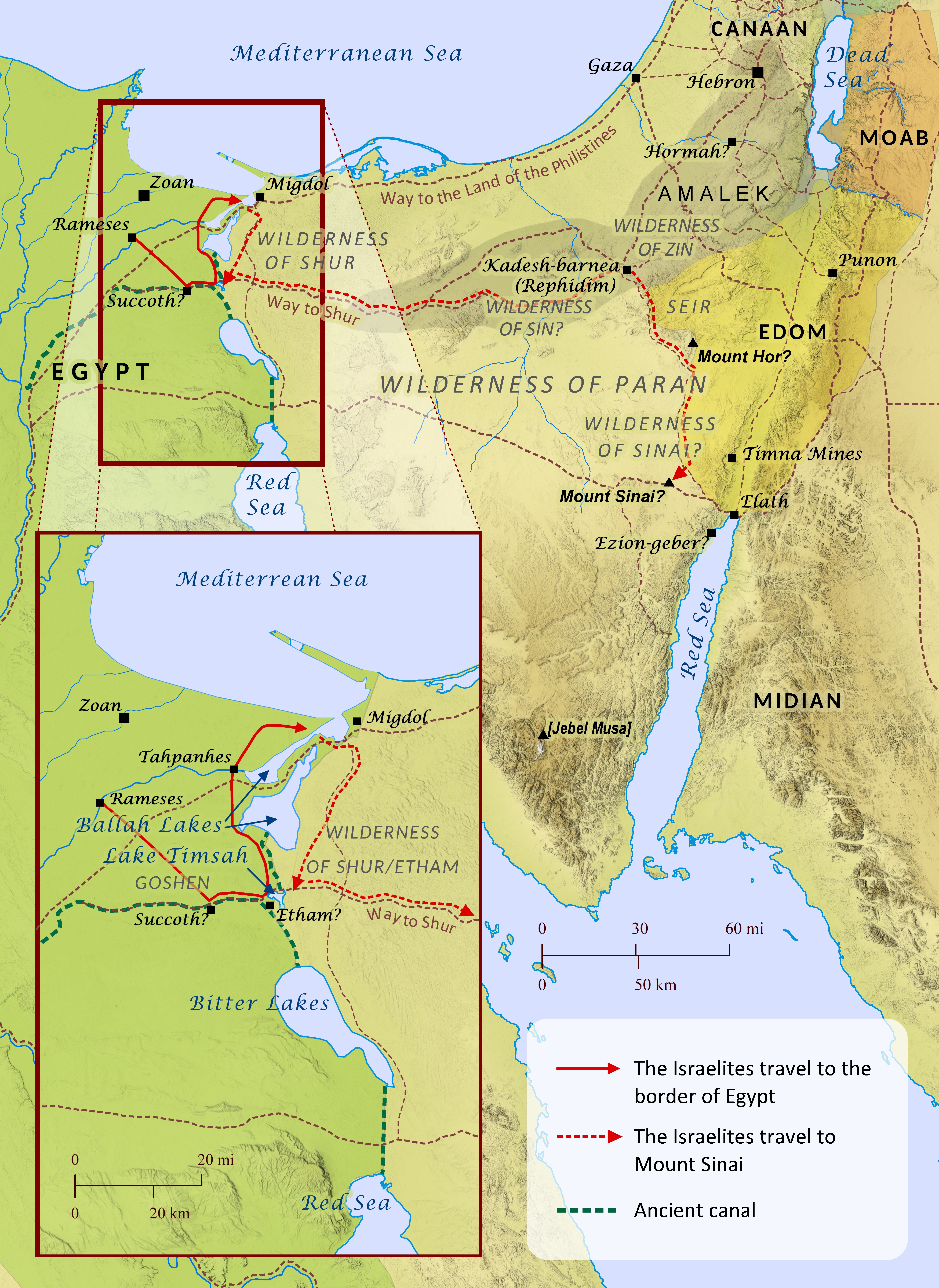
Exodus 13-19; Numbers 33
Like several other events recorded in Scripture, the Bible’s account of the Israelites’ journey from Egypt to Mount Sinai includes an abundance of geographical references, yet it remains one of the most hotly debated topics among scholars, and numerous theories have been offered. The vast majority of geographical references provided in the story are disputed, including the place where the Israelites crossed the Red Sea, the location of Mount Sinai (see Proposed Locations for Mount Sinai map), and the various stops along the Israelites’ journey. A few locations have been established with some degree of scholarly consensus, but even these are not without opposing viewpoints. Amidst this incredible diversity of opinion, however, a single verse provides one of the most helpful clues for weighing the merits of one viewpoint over another: “By the way of Mount Seir it takes eleven days to reach Kadesh-barnea from Horeb” (Deuteronomy 1:2). For those who assume the Bible’s account to be trustworthy, this verse appears to require the following for any theory to be considered viable: 1) Kadesh-barnea and Mount Sinai must have been located at a distance from each other that could reasonably have been expected to take eleven days for an entire nation of people with small children, flocks, equipment, and perhaps even elderly members to travel on foot; and 2) the pace established by this distance over eleven days should most likely be considered the typical pace for the Israelites as they traveled from place to place along the other parts of the journey. This two-pronged test clearly strains many of the theories put forth to this point, especially when one factors in the time references given for the start of the journey (Exodus 12:6; Numbers 33:3), the middle of the journey (Exodus 16:1; Numbers 33:8), and the end of the journey (Exodus 19:1). In short, the journey from Rameses to the Wilderness of Sin took 31 days, since it included the 15th day of the second month, and the rest of the journey took another 16 days, assuming they arrived at Mount Sinai on the 15th day (not the first day, etc.) of the third month. Along with these criteria, a theory’s overall congruence with other established geographical and archeological data should bolster its credibility over other proposals. Another consideration is the extreme similarity between the events at Rephidim (Exodus 17) and the events at Kadesh-barnea (Numbers 20:1-13; 27:12-14; Deuteronomy 32:51; Ezekiel 47:19; 48:28), raising the question of whether Rephidim (meaning “resting places”) is in fact Kadesh-barnea. With these things in mind, the map below proposes a route for the exodus that meets virtually all of these criteria. A careful analysis and explanation of all the elements of the map is far beyond the scope of this article, but a few key points should be noted. The term Red Sea, in addition to referring to what we now regard it, must have also applied to the interconnected lakes and marshlands that lay along what is now the Suez Canal. Also, the portion of the journey that passed through the wilderness for three days without water (Exodus 15:22; Numbers 33:8) may have been comprised of a partial first day, a full second day, and a partial third day, much like Jesus’ time in the tomb is reckoned as three days in Matthew 12:40. Most notably, Mount Sinai is placed on this map at Gebel Khashm et-Tarif, which is appropriately located near, but not in, Midian (Exodus 3:1; 18:5; Numbers 10:29-30). It is also located 89 miles from Kadesh-barnea (assuming Kadesh is at Tall al-Quderat), which establishes a reasonable pace of 7.6 miles (12.2 km) per day to travel between them in 11 days. This lines up well with several known sources of water along that route (e.g., `Ain Qedeis [Hazar-addar?], Tamilat Suwelima [Hor-haggiggad?], and the spring at Kuntillet al-Girafi [unknown ancient identification]). This general pace then synchronizes very well with the timetable and distances required by this map for the other parts of the journey. The distance from Rameses to the Wilderness of Sin (where it is located here) could be completed in under 26 days, leaving an acceptable buffer of about 5 days for the parting of the Red Sea and perhaps a slower pace through the Wilderness of Shur/Etham. The entire journey took about 60 days, and the journey from the Wilderness of Sin to Mount Sinai took about 29 days. This leaves an acceptable buffer of time to complete the rest of the journey (about 16 days of travel) with a very adequate two weeks of extra time for Jethro to visit Moses and the Israelites to do battle with the Amalekites (Exodus 17-18). It should be noted that this timetable generally assumes (but does not necessarily require) that travel continued on sabbath days, but Scripture does not make clear whether travel was prohibited as work prior to the giving of the law at Mount Sinai.
EXO Intro C1 C2 C3 C4 C5 C6 C7 C8 C9 C10 C11 C12 C13 C14 C15 C16 C17 C18 C19 C20 C21 C22 C23 C24 C25 C26 C27 C28 C29 C30 C31 C32 C33 C34 C35 C36 C37 C38 C39 C40