Open Bible Data Home About News OET Key
OET OET-RV OET-LV ULT UST BSB MSB BLB AICNT OEB WEBBE WMBB NET LSV FBV TCNT T4T LEB BBE Moff JPS Wymth ASV DRA YLT Drby RV SLT Wbstr KJB-1769 KJB-1611 Bshps Gnva Cvdl TNT Wycl SR-GNT UHB BrLXX BrTr Related Topics Parallel Interlinear Reference Dictionary Search
OET By Document By Section By Chapter Details
OET GEN EXO LEV NUM DEU JOB JOS JDG RUTH 1 SAM 2 SAM PSA AMOS HOS 1 KI 2 KI 1 CHR 2 CHR PROV ECC SNG JOEL MIC ISA ZEP HAB JER LAM YNA NAH OBA DAN EZE EZRA EST NEH HAG ZEC MAL YHN MARK MAT LUKE ACTs YAC GAL 1 TH 2 TH 1 COR 2 COR ROM COL PHM EPH PHP 1 TIM TIT 1 PET 2 PET 2 TIM HEB YUD 1 YHN 2 YHN 3 YHN REV
DEU Intro C1 C2 C3 C4 C5 C6 C7 C8 C9 C10 C11 C12 C13 C14 C15 C16 C17 C18 C19 C20 C21 C22 C23 C24 C25 C26 C27 C28 C29 C30 C31 C32 C33 C34
33 This is the blessing with which the man of God, Mosheh (Moses), blessed Israelis just before his death:
2 “Yahweh came from Mt. Sinai came
≈ and appeared to them from Mt. Seir—
shining out from Mt. Paran.
He came with ten thousands of holy ones,
holding lightning for them in his right hand.
All his holy ones are in your hand.
They listen to your instructions:
4 Mosheh gave us those instructions
that would become a valuable possession for Yakov’s descendants.
5 Yahweh became king over Yeshurun,[fn]
when the leaders of the people had gathered—
Yisrael’s tribes all together.
6 Let Reuven live and not die,
7 Then he said this is for Yehudah (Judah),
“Yahweh, listen to Yehudah’s voice,
and take him to his people.
He defended himself,
plus you help him against his enemies.”
“Your Thummim and your Urim
≈ You strove against him at the Merivah springs.[ref]
9 He said that he hadn’t seen his father and his mother,
≈ and he didn’t acknowledge his brothers or spend time with his sons.
because he guarded your message
10 He teaches your rules to Yakov,
≈ and your instructions to Yisrael.
He’ll burn fragrant incense for you,
≈ and whole burnt offerings on your altar.
11 Yahweh, bless Yisrael’s possessions,
and accept the work that he does.
Crush those who take action up against him,
and those who hate, in case they attack.”
“Yahweh’s special one lives in security beside him.
He protects him all day long,
≈ and Yahweh places him on his chest.”
13 To Yosef (Joseph), he said,
with the rain from the sky,
≈ from the dew and from the springs lying beneath,
14 with a plentiful harvest from the good sunshine,
≈ and from the bounty of the produce of the seasons,
15 and water from the tops of ancient mountains,
and from the bounty of age-old hills,
16 and from the bounty of the soil and from its fullness,
and the favour of the bush-dweller.
Let them come on Yosef’s head,
and on the top of the head of the leader of his brothers.
17 His majesty is like his firstborn bull,
≈ and his horns are like the horns of a wild bull.
He’ll ram the peoples with them,
together to the ends of the earth.
And they are the ten thousands of Efrayim,
≈ and they are the thousands of Menashsheh.”
“Zevulun, be happy when you go out,
and Yissakar too, in your tents.
19 They will call peoples to the mountain.
There they will offer sacrifices of righteousness.
because they feed on the abundance of the oceans,
and on treasures hidden in the sand.”
“Blessed be the one who enlarges Gad.
He’ll live like a lioness,
and tear off an arm, perhaps also a head.
21 He picked out the best for himself,
because there the decreed portion is reserved.
He came with the people’s leaders.
He administered Yahweh’s justice,
and his judgements for Yisrael.”
“Dan is a lion cub
leaping out from Bashan.”
“Naftali, overflowing with favour,
≈ and full of Yahweh’s blessings,
you’ll possess the west and the south.”
“Asher is blessed among the sons.
≈ Let him be favoured among his brothers,
and enjoy having lots of olive oil.
25 Your gates will have iron and bronze bars,
≈ and you’ll be strong all your life.
26 There’s no one else like Yeshurun’s God,
riding the heavens to your help,
≈ and in his majesty on the clouds.
27 The everlasting God is a place of safety,
and it’s his eternal arms that are underneath you.
He drove the enemy away from in front of you,
and he said, ‘Destroy them.’
28 Israel will live in safety—
in a land of grain and new wine
where the skies above them drop dew.
Who else is like you—a people saved by Yahweh,
the shield that protects you,
and who is the sword that makes you powerful?
Your enemies will cringe back from you,
and you’ll trample all over their hills.”
33:5 Yeshurun means ‘the upright one’, a term of endearment for Yisrael, also in verse 26.
33:2 OSHB variant note: אשדת: (x-qere) ’אֵ֥שׁ’: lemma_784 morph_HNcbsc id_059bG אֵ֥שׁ ’דָּ֖ת’: lemma_1881 n_0.0 morph_HNcfsa id_05UNy דָּ֖ת
33:9 OSHB variant note: בנ/ו: (x-qere) ’בָּנָ֖י/ו’: lemma_1121 a n_1.0 morph_HNcmpc/Sp3ms id_05HDg בָּנָ֖י/ו
33:28 OSHB note: We read the punctuation in L differently from BHQ.
33:28 OSHB note: We read one or more accents in L differently than BHS. Often this notation indicates a typographical error in BHS.
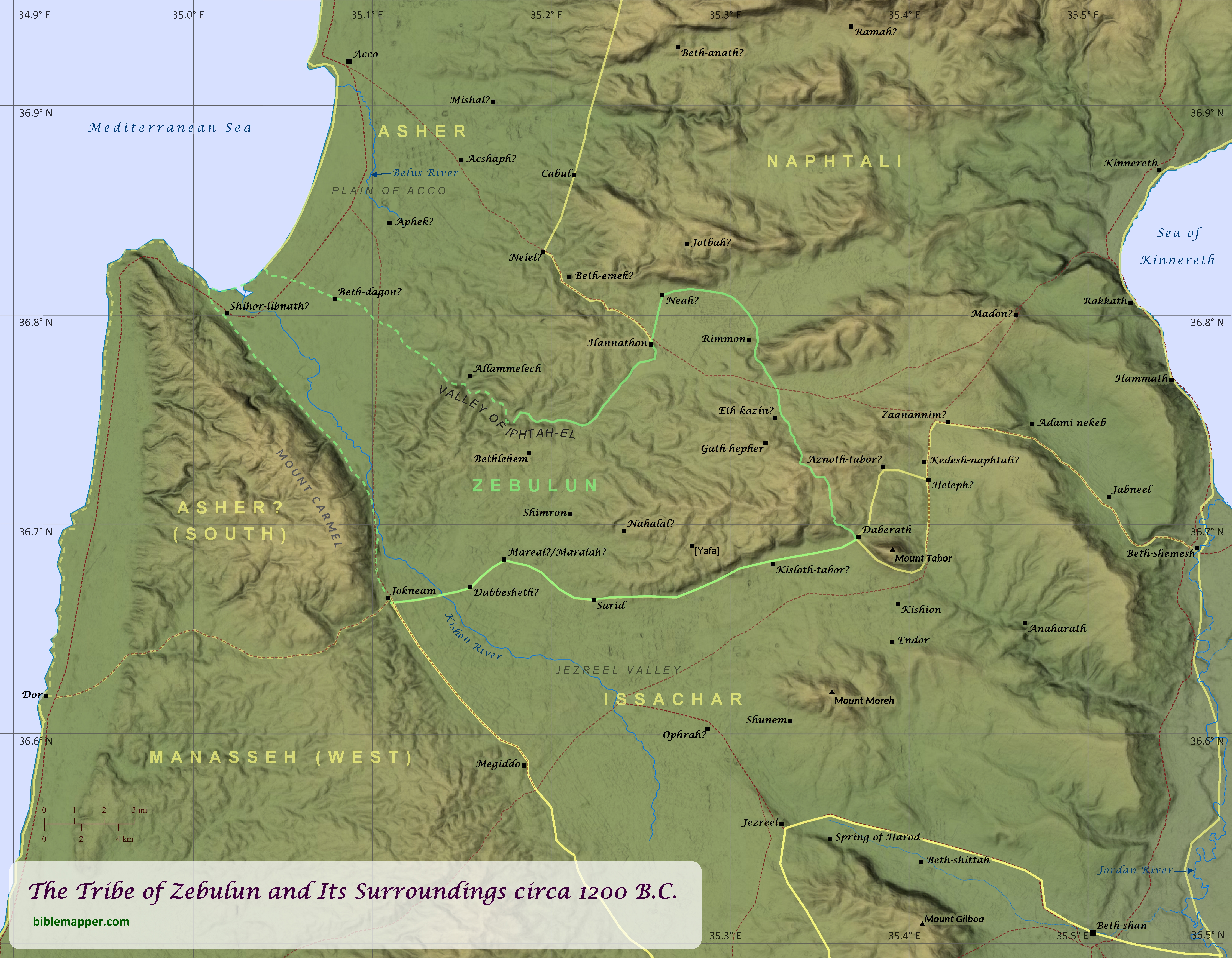
When recounting which Israelite tribes played an important role the history of the nation, it is unlikely that Zebulun and its neighboring tribes would be among the first named by most Bible readers. Yet a careful study of Scripture reveals that this region played a key role in the life of Israel from its earliest years until the time of Jesus. During the time of Israel’s conquest of Canaan, this region was the site of a momentous victory over the forces of the Canaanite King Jabin of Hazor (Joshua 11; see “The Conquest of Canaan: The Northern Campaign” map). Likewise the prophet Deborah called upon Barak to lead an army of Israelites from the tribes of Naphtali and Zebulun to fight against another King Jabin near Mount Tabor (Judges 4-5; see “Deborah and Barak Defeat Sisera” map). Later in the time of the judges, Gideon and his men from Manasseh, Asher, Zebulun, and Naphtali ambushed a vast army of Midianites, Amalekites, and peoples of the East in the Jezreel Valley (Judges 6-8; see “Gideon Defeats the Midianites” map). Mount Tabor also appears to have been a common cultic center for the surrounding tribes throughout the Old Testament (see Deuteronomy 33:18-19). As such, Tabor does not appear to have been included within any of the tribes’ allotted territory (see Joshua 19), although three of the tribes bordered it (see “Mount Tabor and Its Surrounding Tribal Boundaries” map), and Tabor is reckoned as belonging to Zebulun in the assignment of towns for the Levites (1 Chronicles 6:77). Saul also led the Israelites into battle against a coalition of of Philistine forces in the Jezreel Valley, and he and his sons were killed on Mount Gilboa (1 Samuel 28-31; 1 Chronicles 10; see “The Battle at Mount Gilboa” map).
Over the next few centuries, the northern tribes of Israel experienced multiple attacks and occupations by foreign powers, including by Aram and Babylonia (2 Kings 16-17; 2 Chronicles 28; Isaiah 7-8; see “Border Conflict between Israel and Judah” and “The Final Days of the Northern Kingdom of Israel” maps). In the time of Elijah, King Ahab had a palace in Jezreel, and Elijah challenged the prophets of Baal to a contest on Mount Carmel to see whether Baal or the Lord was truly God. After the people saw that the Lord indeed was God, they killed the prophets of Baal at the Kishon River (1 Kings 18-19; see “Elijah Challenges Ahab” map). Elijah’s student Elisha sometimes stayed at the home of a woman in Shunem, and after her son died, Elisha raised him back to life (2 Kings 4:1-37). Later, King Josiah of Judah was killed at Megiddo as he tried to stop Pharaoh Neco from coming to the aid of the collapsing Assyrian Empire (2 Kings 22-23; 2 Chronicles 34-35; see “Josiah Battles Neco” map). Centuries later the tiny village of Nazareth, located in the tribe of Zebulun, became home to Jesus the Messiah (Matthew 2:19-23; see “Nazareth and Its Surroundings” map), fulfilling the prophecy of Isaiah that “the land of Zebulun and the land of Naphtali, the way of the sea, beyond the Jordan, Galilee of the Gentiles–the people dwelling in darkness have seen a great light, and for those dwelling in the region and shadow of death, on them a light has dawned” (Matthew 4:15-16).
The exact borders of these northern tribes, specifically of Zebulun, Asher, and Manasseh, has been the subject of some debate over the centuries. The borders are carefully delineated in Joshua 19. There the boundaries given for Asher do not include the region of Mount Carmel and Dor, yet two chapters earlier (see Joshua 17:11) the author indicates that Dor (and probably Mount Carmel) did fall within the boundaries of Asher, though it was occupied by Manasseh. Adding to the confusion is Joshua 19:26, which notes that Asher’s territory bordered (“touches”) Carmel and Shihor-libnath, which may have referred to a specific town, but it may also have encompassed the greater alluvial plain of the lower Kishon River. The mouth of the Kishon River as well as the mouth of the Belus River further north were known in ancient times for their glassmaking industries (it is mentioned by both Tacitus, The Histories, 5.7, and Pliny the Elder, Natural History, 5.19), and the name Shihor-libnath means “river of glass/whiteness.” This description of Asher’s border seems to suggest that Zebulun was landlocked, and it is shown this way in virtually every map of the region available today. Yet in the blessings of both Jacob and Moses, Zebulun is associated with the abundance of the sea (Genesis 49:13; Deuteronomy 33:18-19), suggesting that it bordered the sea. A possible resolution for both of these questions (whether Dor was within Asher’s territory and whether Zebulun bordered the sea) may be found in this author’s new understanding of Zebulun’s western border, as shown on this map. (I have since found two maps from 1823 by that display similar borders; see footnote below.) Given that Asher’s border is described as starting at the edge of Carmel and Shihor-libnath and then heading east (not southeast; Joshua 19:26), it stands to reason that a different tribe occupied the area to the southeast of Shihor-libnath. The most fitting candidate for this other tribe is Zebulun, since this would also explain its association with the sea. This may also explain why the region of Dor and Carmel, which would have been separated from northern Asher by Zebulun and was occupied by Manasseh even by the time of the completion of the book of Joshua, does not appear to have been regarded as part of the principle territory of Asher.
Two older works containing similar boundaries for Zebulun are:
Geographia Sacra, or Scripture Atlas, Comprising A Complete Set of Maps adapted to elucidate the Events of Sacred History which point out the Situation of every place mentioned in the Old & New Testaments. By J. Wyld, 1823.
The Bible Atlas; or, Sacred Geography Delineated, In A Complete Series of Scriptural Maps, Drawn From The Latest and Best Authorities, and Engraved By Richard Palmer, 1823.
DEU Intro C1 C2 C3 C4 C5 C6 C7 C8 C9 C10 C11 C12 C13 C14 C15 C16 C17 C18 C19 C20 C21 C22 C23 C24 C25 C26 C27 C28 C29 C30 C31 C32 C33 C34