Open Bible Data Home About News OET Key
OET OET-RV OET-LV ULT UST BSB MSB BLB AICNT OEB WEBBE WMBB NET LSV FBV TCNT T4T LEB BBE Moff JPS Wymth ASV DRA YLT Drby RV SLT Wbstr KJB-1769 KJB-1611 Bshps Gnva Cvdl TNT Wycl SR-GNT UHB BrLXX BrTr Related Topics Parallel Interlinear Reference Dictionary Search
ParallelVerse GEN EXO LEV NUM DEU JOB JOS JDG RUTH 1 SAM 2 SAM PSA AMOS HOS 1 KI 2 KI 1 CHR 2 CHR PROV ECC SNG JOEL MIC ISA ZEP HAB JER LAM YNA (JNA) NAH OBA DAN EZE EZRA EST NEH HAG ZEC MAL LAO GES LES ESG DNG 2 PS TOB JDT ESA WIS SIR BAR LJE PAZ SUS BEL MAN 1 MAC 2 MAC 3 MAC 4 MAC YHN (JHN) MARK MAT LUKE ACTs YAC (JAM) GAL 1 TH 2 TH 1 COR 2 COR ROM COL PHM EPH PHP 1 TIM TIT 1 PET 2 PET 2 TIM HEB YUD (JUD) 1 YHN (1 JHN) 2 YHN (2 JHN) 3 YHN (3 JHN) REV
Jos Intro C1 C2 C3 C4 C5 C6 C7 C8 C9 C10 C11 C12 C13 C14 C15 C16 C17 C18 C19 C20 C21 C22 C23 C24
Jos 19 V1 V3 V5 V7 V9 V13 V15 V17 V19 V21 V23 V25 V27 V29 V31 V33 V35 V37 V39 V41 V43 V45 V47 V49 V51
Note: This view shows ‘verses’ which are not natural language units and hence sometimes only part of a sentence will be visible—click on any Bible version abbreviation down the left-hand side to see the verse in more of its context. Normally the OET discourages the reading of individual ‘verses’, but this view is only designed as a tool for Bible-translators and others doing comparisons of different translations—the older translations are further down the page (so you can read up from the bottom to trace the English translation history). The OET segments on this page are still early looks into the drafted texts of the Open English Translation of the Bible—please double-check these texts in advance before using in public.
Text critical issues=none Clarity of original=clear Importance to us=normal (All still tentative.)
OET (OET-RV) and went west to Maralah and Dabbeshet then to the riverbed facing Yokneam.![]()
OET-LV border_of_their And_he/it_would_go_up to_west and_Marʼₐlāh and_it_touches (on)_Dabeshet and_it_touches (to) the_wadi which is_on the_face_of Yāqənəˊām/(Jokneam).
![]()
UHB וְעָלָ֨ה גְבוּלָ֧ם ׀ לַיָּ֛מָּה וּמַרְעֲלָ֖ה וּפָגַ֣ע בְּדַבָּ֑שֶׁת וּפָגַע֙ אֶל־הַנַּ֔חַל אֲשֶׁ֖ר עַל־פְּנֵ֥י יָקְנְעָֽם׃ ‡
(vəˊālāh gəⱱūlām layyāmmāh ūmarˊₐlāh ūfāgaˊ bədabāshet ūfāgaˊ ʼel-hannaḩal ʼₐsher ˊal-pənēy yāqənəˊām.)
Key: khaki:verbs.
Note: Automatic aligning of the OET-RV to the LV is done by some temporary software, hence the OET-RV alignments are incomplete (and may occasionally be wrong).
BrLXX ἡ θάλασσα καὶ Μαγελδὰ, καὶ συνάψει ἐπὶ Βαιθάραβὰ εἰς τὴν φάραγγα, ἥ ἐστι κατὰ πρόσωπον Ἰεκμάν.
(haʸ thalassa kai Magelda, kai sunapsei epi Baitharaba eis taʸn faranga, haʸ esti kata prosōpon Iekman.)
BrTr the sea and Magelda, and it shall reach to [fn]Bætharaba in the valley, which is opposite Jekman.
19:11 Or, at or towards.
ULT And their border went up toward the sea and Maralah, and it met with Dabbesheth and met with the wadi that is on the face of Jokneam.
UST It extended west to Maralah and on to Dabbesheth, and then it extended to the brook in front of the city of Jokneam.
BSB [It] went up westward to Maralah, reached Dabbesheth, and met the brook east of Jokneam.
MSB (Same as BSB above)
OEB then westward to Maralah, stretching to Dabbesheth and to the valley east of Jokneam.
WEBBE Their border went up westward, even to Maralah, and reached to Dabbesheth. It reached to the brook that is before Jokneam.
WMBB (Same as above)
NET Their border went up westward to Maralah and touched Dabbesheth and the valley near Jokneam.
LSV and their border has gone up toward the sea, and Maralah, and come against Dabbasheth, and come to the brook which [is] on the front of Jokneam,
FBV and then went west past Maralah, touched Dabbeshah, and then the brook near Jokneam.
T4T It extended west to Maralah city and on to Dabbesheth city, and on to the brook just north of Jokneam city.
LEB Their border goes up to the west, to Maralah; it touches[fn] Dabbesheth, then the wadi[fn] that is opposite Jokneam.
19:11 Or “reaches to”
19:11 A valley that is dry most of the year, but contains a stream during the rainy season
BBE And their limit goes up to the west to Maralah, stretching to Dabbesheth, and to the stream in front of Jokneam;
Moff then westward to Maralah, stretching to Dabbesheth and to the brook east of Jokneam;
JPS And their border went up westward, even to Maralah, and reached to Dabbesheth; and it reached to the brook that is before Jokneam.
ASV and their border went up westward, even to Maralah, and reached to Dabbesheth; and it reached to the brook that is before Jokneam;
DRA And it went up from the sea and from Merala, and came to Debbaseth: as far as the torrent, which is over against Jeconam.
YLT and their border hath gone up towards the sea, and Maralah, and come against Dabbasheth, and come unto the brook which [is] on the front of Jokneam,
Drby and their border went up westwards, and [to] Marealah, and reached to Dabbesheth, and reached to the torrent that is before Jokneam;
RV and their border went up westward, even to Maralah, and reached to Dabbesheth; and it reached to the brook that is before Jokneam;
SLT And their bound went up to the sea and Maralah, and struck upon Dabbasheth, and struck into the torrent which is upon the face of Jokneam,
Wbstr And their border went up towards the sea, and Maralah, and reached to Dabbasheth, and reached to the river that is before Jokneam,
KJB-1769 And their border went up toward the sea, and Maralah, and reached to Dabbasheth, and reached to the river that is before Jokneam;
KJB-1611 And their border went vp toward the Sea, and Maralah, and reached to Dabbasheth, and reached to the riuer that is before Iokneam,
(Modernised spelling is same as from KJB-1769 above, apart from capitalisation and punctuation)
Bshps And went vp westward euen to Maralah, and reached to Dabbaseth, & came thence to the riuer that lyeth before Iokneam.
(And went up westward even to Maralah, and reached to Dabbaseth, and came thence to the river that lieth/lies before Yokneam.)
Gnva And their border goeth vp Westwarde, euen to Maralah, and reacheth to Dabbasheth, and meeteth with the riuer that lyeth before Iokneam,
(And their border goeth/goes up Westwarde, even to Maralah, and reacheth to Dabbasheth, and meeteth/meets with the river that lieth/lies before Yokneam,)
Cvdl & goeth vp westwarde to Mareala, & bordreth vpon Dabaseth, and reacheth vnto the ryuer that floweth ouer agaynst Iakneam:
(and goeth/goes up westward to Mareala, and bordreth upon Dabaseth, and reacheth unto the river that floweth/flows over against Yakneam:)
Wycl and it stieth fro the see, and Medala; and it cometh in to Debbaseth, `til to the stronde which is ayens Jecenam;
(and it stieth from the sea, and Medala; and it cometh/comes in to Debbaseth, till to the stream/river which is against Yecenam;)
Luth und gehet hinauf zu abendwärts gen Mareala und stößet an Dabaseth und stößet an den Bach, der vor Jakneam fleußt;
(and goes up to/for evening to/toward Mareala and prods/pushes/bumps at/to Dabaseth and prods/pushes/bumps at/to the stream(n), the/of_the before/in_front_of Yakneam flows;)
ClVg Ascenditque de mari et Merala, et pervenit in Debbaseth, usque ad torrentem qui est contra Jeconam.
(And_he_ascended from/about of_the_sea and Merala, and arrived in/into/on Debbaseth, until to torrent who/which it_is on_the_contrary Yeconam.)
It went up westward to Maralah,
The border went west to the town of Maralah.
From there the boundary went west to the town of Maralah,
It went up westward to Maralah: The clause went up westward to Maralah indicates that the boundary line continued westward from Sarid town. The southern boundary line of Zebulun’s land followed the course of the Kishon River.Aharoni p. 257. The Kishon River flows from east to northwest through the Valley of Jezreel and enters the Mediterranean Sea at the port of Haifa.
Maralah: It is not certain where this town was located.
There is an interpretation issue with the term Maralah. Bible scholars divide the Hebrew words in two different ways.
The name of the town is Maralah. (BSB, NRSV, NIV, NASB, NJPS, NET, NLT, GW, REB, NJB, CEV, KJV)
The name of the town is Mareal. The Hebrew word “Maralah” should be separated into “Mareal” and “-ah.” The last syllable -ah is a Hebrew directional. (RSV, ESV, NABRE, GNT)
It is recommended that you follow option (1). Most English versions and most Bible atlasesRasmussen p.244; Aharoni p, 257. refer to the name of this town as Maralah.
Here are some other ways to translate this part of the verse:
The border went west to the town of Maralah
From there the boundary ran on to the town of Maralah
reached Dabbesheth,
Then it went on to the town of Dabbesheth.
and continued to the town of Dabbesheth.
reached Dabbesheth: The clause reached Dabbesheth indicates that the southern border continued to the town of Dabbesheth.
Here are some other ways to translate this part of the verse:
then it went on to the town of Dabbesheth
and continued to the town of Dabbesheth
and met the brook east of Jokneam.
The border then went on to the stream near the town of Jokne-am.
Then it went on to the river valley near the town of Jokne-am.
met the brook east of Jokneam: The phrase the brook east of Jokneam refers to a streambed that flowed with water in certain seasons. It was near the town of Jokneam.
east: The Hebrew word that the BSB translates as east is more literally “on the face of.” There are two ways to interpret this word.
It means “near” or “opposite.” For example:
the ravine near Jokneam (NIV) (NIV, NET, NASB, GW, NJPS, NJB, NABRE, CEV, KJV)
It means “east.” For example:
the stream east of Jokneam (GNT) (BSB, GNT, RSV, ESV, REB, NLT)
It is recommended that you follow interpretation (1). We do not know for certain where the brook was in relation to Jokneam town. It is best to translate it using a word that means “near” or “close to.”
Here are some other ways to translate this part of the verse:
The border then went on to the streambed near the town of Jokne-am
It reached the wadi near the town of Jokne-am
Note 1 topic: figures-of-speech / metonymy
עַל־פְּנֵ֥י
on/upon/above/on_account_of//he/it_went_in (Some words not found in UHB: and=he/it_would_go_up border_of,their to,west, and,Maralah and,it_touches (on),Dabbesheth and,it_touches to/towards the,wadi which/who on/upon/above/on_account_of//he/it_went_in face/surface_of Yāqənəˊām/(Jokneam) )
See the Introduction to Joshua for a discussion of the phrase “the face of.” Alternate translation: [is before] or [is opposite]
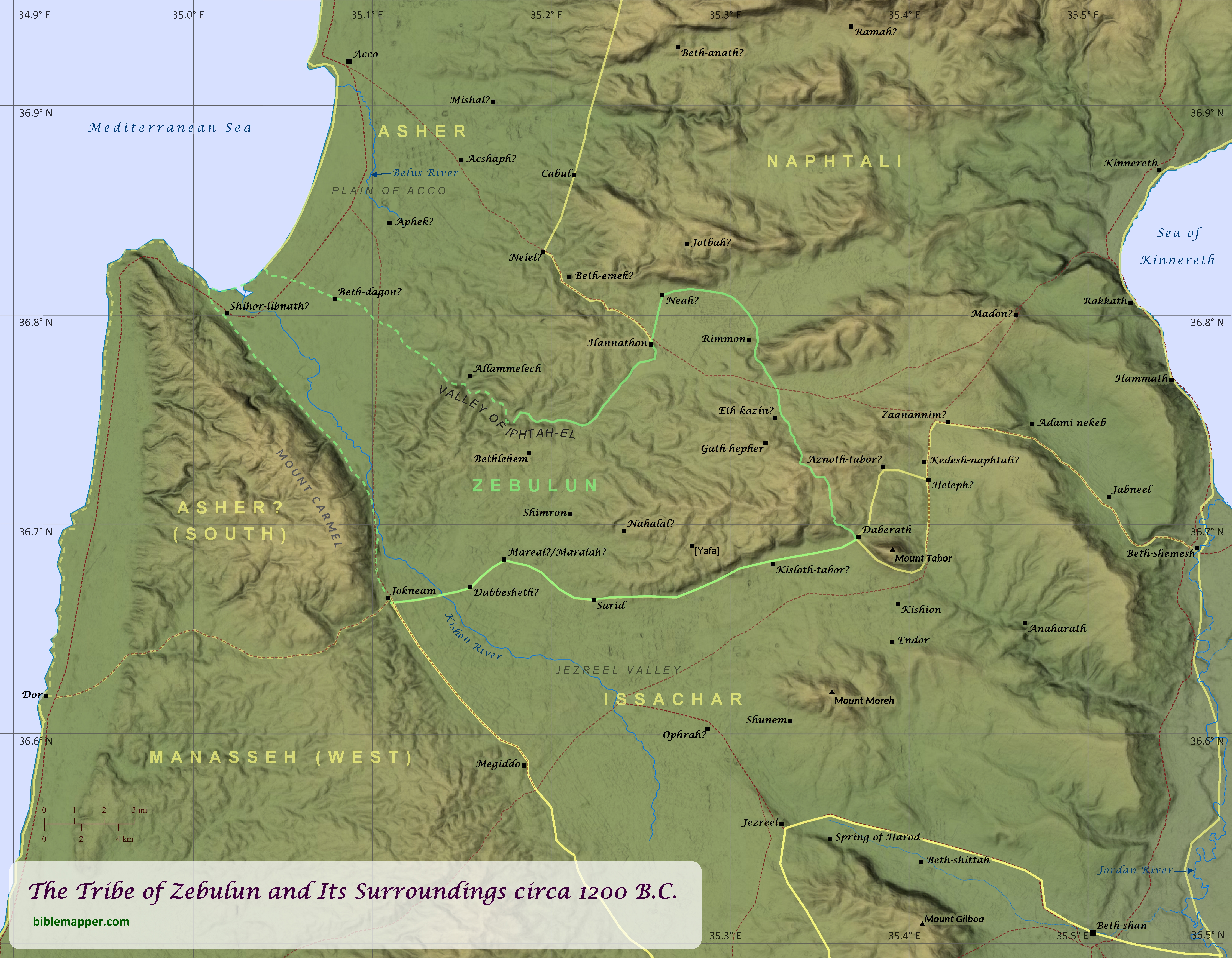
When recounting which Israelite tribes played an important role the history of the nation, it is unlikely that Zebulun and its neighboring tribes would be among the first named by most Bible readers. Yet a careful study of Scripture reveals that this region played a key role in the life of Israel from its earliest years until the time of Jesus. During the time of Israel’s conquest of Canaan, this region was the site of a momentous victory over the forces of the Canaanite King Jabin of Hazor (Joshua 11; see “The Conquest of Canaan: The Northern Campaign” map). Likewise the prophet Deborah called upon Barak to lead an army of Israelites from the tribes of Naphtali and Zebulun to fight against another King Jabin near Mount Tabor (Judges 4-5; see “Deborah and Barak Defeat Sisera” map). Later in the time of the judges, Gideon and his men from Manasseh, Asher, Zebulun, and Naphtali ambushed a vast army of Midianites, Amalekites, and peoples of the East in the Jezreel Valley (Judges 6-8; see “Gideon Defeats the Midianites” map). Mount Tabor also appears to have been a common cultic center for the surrounding tribes throughout the Old Testament (see Deuteronomy 33:18-19). As such, Tabor does not appear to have been included within any of the tribes’ allotted territory (see Joshua 19), although three of the tribes bordered it (see “Mount Tabor and Its Surrounding Tribal Boundaries” map), and Tabor is reckoned as belonging to Zebulun in the assignment of towns for the Levites (1 Chronicles 6:77). Saul also led the Israelites into battle against a coalition of of Philistine forces in the Jezreel Valley, and he and his sons were killed on Mount Gilboa (1 Samuel 28-31; 1 Chronicles 10; see “The Battle at Mount Gilboa” map).
Over the next few centuries, the northern tribes of Israel experienced multiple attacks and occupations by foreign powers, including by Aram and Babylonia (2 Kings 16-17; 2 Chronicles 28; Isaiah 7-8; see “Border Conflict between Israel and Judah” and “The Final Days of the Northern Kingdom of Israel” maps). In the time of Elijah, King Ahab had a palace in Jezreel, and Elijah challenged the prophets of Baal to a contest on Mount Carmel to see whether Baal or the Lord was truly God. After the people saw that the Lord indeed was God, they killed the prophets of Baal at the Kishon River (1 Kings 18-19; see “Elijah Challenges Ahab” map). Elijah’s student Elisha sometimes stayed at the home of a woman in Shunem, and after her son died, Elisha raised him back to life (2 Kings 4:1-37). Later, King Josiah of Judah was killed at Megiddo as he tried to stop Pharaoh Neco from coming to the aid of the collapsing Assyrian Empire (2 Kings 22-23; 2 Chronicles 34-35; see “Josiah Battles Neco” map). Centuries later the tiny village of Nazareth, located in the tribe of Zebulun, became home to Jesus the Messiah (Matthew 2:19-23; see “Nazareth and Its Surroundings” map), fulfilling the prophecy of Isaiah that “the land of Zebulun and the land of Naphtali, the way of the sea, beyond the Jordan, Galilee of the Gentiles–the people dwelling in darkness have seen a great light, and for those dwelling in the region and shadow of death, on them a light has dawned” (Matthew 4:15-16).
The exact borders of these northern tribes, specifically of Zebulun, Asher, and Manasseh, has been the subject of some debate over the centuries. The borders are carefully delineated in Joshua 19. There the boundaries given for Asher do not include the region of Mount Carmel and Dor, yet two chapters earlier (see Joshua 17:11) the author indicates that Dor (and probably Mount Carmel) did fall within the boundaries of Asher, though it was occupied by Manasseh. Adding to the confusion is Joshua 19:26, which notes that Asher’s territory bordered (“touches”) Carmel and Shihor-libnath, which may have referred to a specific town, but it may also have encompassed the greater alluvial plain of the lower Kishon River. The mouth of the Kishon River as well as the mouth of the Belus River further north were known in ancient times for their glassmaking industries (it is mentioned by both Tacitus, The Histories, 5.7, and Pliny the Elder, Natural History, 5.19), and the name Shihor-libnath means “river of glass/whiteness.” This description of Asher’s border seems to suggest that Zebulun was landlocked, and it is shown this way in virtually every map of the region available today. Yet in the blessings of both Jacob and Moses, Zebulun is associated with the abundance of the sea (Genesis 49:13; Deuteronomy 33:18-19), suggesting that it bordered the sea. A possible resolution for both of these questions (whether Dor was within Asher’s territory and whether Zebulun bordered the sea) may be found in this author’s new understanding of Zebulun’s western border, as shown on this map. (I have since found two maps from 1823 by that display similar borders; see footnote below.) Given that Asher’s border is described as starting at the edge of Carmel and Shihor-libnath and then heading east (not southeast; Joshua 19:26), it stands to reason that a different tribe occupied the area to the southeast of Shihor-libnath. The most fitting candidate for this other tribe is Zebulun, since this would also explain its association with the sea. This may also explain why the region of Dor and Carmel, which would have been separated from northern Asher by Zebulun and was occupied by Manasseh even by the time of the completion of the book of Joshua, does not appear to have been regarded as part of the principle territory of Asher.
Two older works containing similar boundaries for Zebulun are:
Geographia Sacra, or Scripture Atlas, Comprising A Complete Set of Maps adapted to elucidate the Events of Sacred History which point out the Situation of every place mentioned in the Old & New Testaments. By J. Wyld, 1823.
The Bible Atlas; or, Sacred Geography Delineated, In A Complete Series of Scriptural Maps, Drawn From The Latest and Best Authorities, and Engraved By Richard Palmer, 1823.
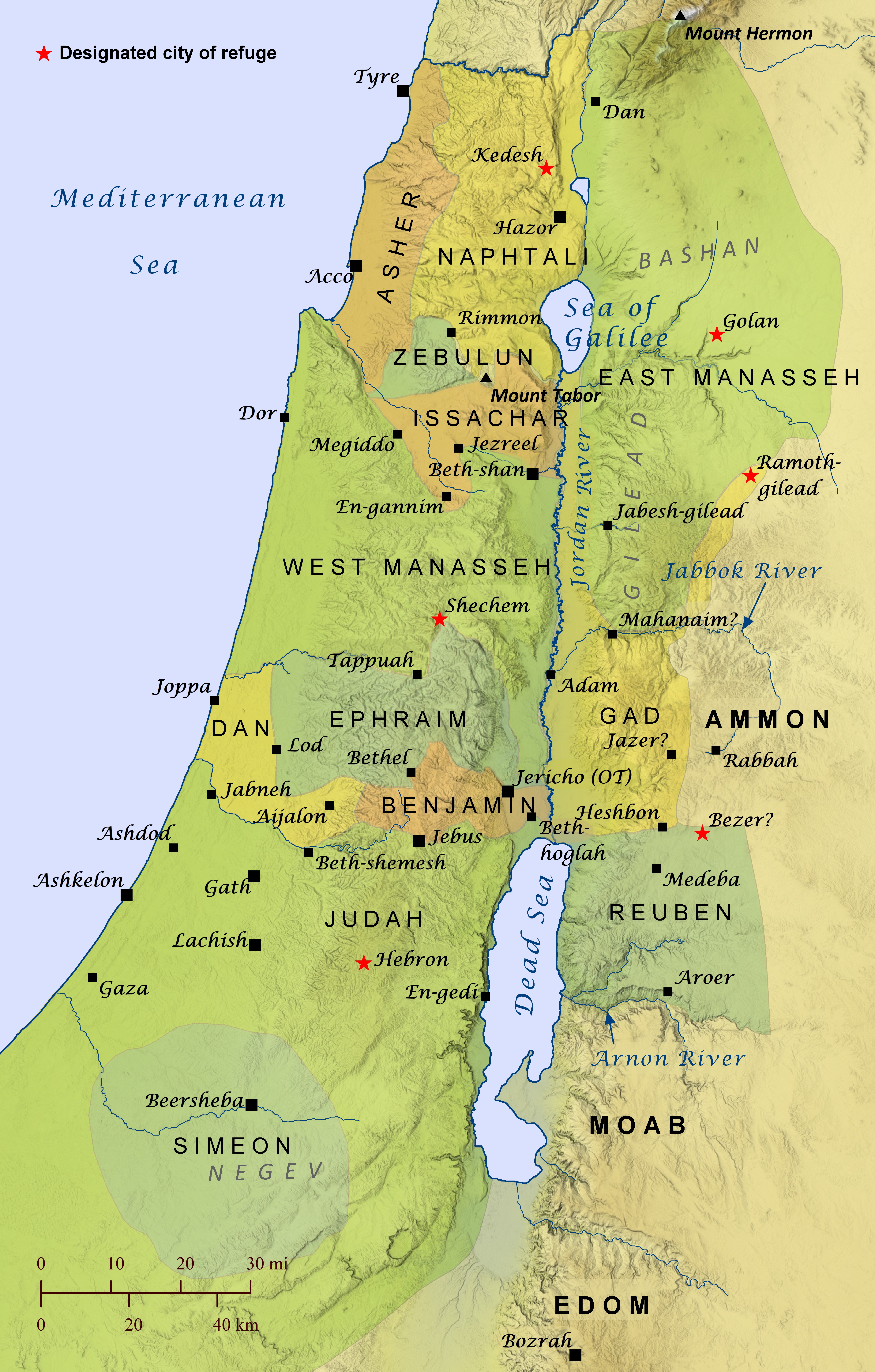
After the Israelites had conquered portions of the Promised Land and Joshua had grown old, the Lord directed him to divide the rest of the land among the tribes of Israel as their inheritance (Joshua 13-20). The eastern tribes had already been allotted their land under Moses’ leadership (Numbers 32), but they continued to help the other tribes drive out the Canaanites from land west of the Jordan River. The Lord also instructed the Israelites to designate several cities of refuge, where someone could flee for protection from an avenger if they accidentally killed someone (Numbers 35; Joshua 20).
Open Bible Data site copyright © 2023–2026 Freely-Given.org.
Python source code for creating these static pages is available on GitHub under an open licence.
For Bible data copyrights, see the details for each displayed Bible version.
![]() The Open English Translation (OET) main site is at OpenEnglishTranslation.Bible or OET.Bible.
The Open English Translation (OET) main site is at OpenEnglishTranslation.Bible or OET.Bible.