⇔ that extend to Ar village along Moav’s border.”)
Open Bible Data Home About News OET Key
OET OET-RV OET-LV ULT UST BSB MSB BLB AICNT OEB WEBBE WMBB NET LSV FBV TCNT T4T LEB BBE Moff JPS Wymth ASV DRA YLT Drby RV SLT Wbstr KJB-1769 KJB-1611 Bshps Gnva Cvdl TNT Wycl SR-GNT UHB BrLXX BrTr Related Topics Parallel Interlinear Reference Dictionary Search
ParallelVerse GEN EXO LEV NUM DEU JOB JOS JDG RUTH 1 SAM 2 SAM PSA AMOS HOS 1 KI 2 KI 1 CHR 2 CHR PROV ECC SNG JOEL MIC ISA ZEP HAB JER LAM YNA (JNA) NAH OBA DAN EZE EZRA EST NEH HAG ZEC MAL LAO GES LES ESG DNG 2 PS TOB JDT ESA WIS SIR BAR LJE PAZ SUS BEL MAN 1 MAC 2 MAC 3 MAC 4 MAC YHN (JHN) MARK MAT LUKE ACTs YAC (JAM) GAL 1 TH 2 TH 1 COR 2 COR ROM COL PHM EPH PHP 1 TIM TIT 1 PET 2 PET 2 TIM HEB YUD (JUD) 1 YHN (1 JHN) 2 YHN (2 JHN) 3 YHN (3 JHN) REV
Num Intro C1 C2 C3 C4 C5 C6 C7 C8 C9 C10 C11 C12 C13 C14 C15 C16 C17 C18 C19 C20 C21 C22 C23 C24 C25 C26 C27 C28 C29 C30 C31 C32 C33 C34 C35 C36
Num 21 V1 V2 V3 V4 V5 V6 V7 V8 V9 V10 V11 V12 V13 V14 V16 V17 V18 V19 V20 V21 V22 V23 V24 V25 V26 V27 V28 V29 V30 V31 V32 V33 V34 V35
Note: This view shows ‘verses’ which are not natural language units and hence sometimes only part of a sentence will be visible—click on any Bible version abbreviation down the left-hand side to see the verse in more of its context. Normally the OET discourages the reading of individual ‘verses’, but this view is only designed as a tool for Bible-translators and others doing comparisons of different translations—the older translations are further down the page (so you can read up from the bottom to trace the English translation history). The OET segments on this page are still early looks into the drafted texts of the Open English Translation of the Bible—please double-check these texts in advance before using in public.
Text critical issues=small word differences Clarity of original=clear Importance to us=normal (All still tentative.)
OET (OET-RV) and the sloping valleys there,
⇔ that extend to Ar village along Moav’s border.”)![]()
OET-LV And_the_slope_of the_wadis which it_extends to_the_dwelling of_ˊĀr and_it_leans to_the_border_of Mōʼāⱱ.
![]()
UHB וְאֶ֨שֶׁד֙ הַנְּחָלִ֔ים אֲשֶׁ֥ר נָטָ֖ה לְשֶׁ֣בֶת עָ֑ר וְנִשְׁעַ֖ן לִגְב֥וּל מוֹאָֽב׃ ‡
(vəʼeshed hannəḩālim ʼₐsher nāţāh ləsheⱱet ˊār vənishˊan ligəⱱūl mōʼāⱱ.)
Key: khaki:verbs.
Note: Automatic aligning of the OET-RV to the LV is done by some temporary software, hence the OET-RV alignments are incomplete (and may occasionally be wrong).
BrLXX Καὶ τοὺς χιμάῤῥους κατέστησε κατοικίσαι Ἤρ· καὶ πρόσκειται τοῖς ὁρίοις Μωάβ.
(Kai tous ⱪimaɽɽous katestaʸse katoikisai Aʸr; kai proskeitai tois horiois Mōab.)
BrTr And he has appointed brooks to cause Er to dwell there; and it lies near to the coasts of Moab.
ULT and the slope of the wadis
⇔ that stretches out to the seat of Ar
⇔ and leans to the border of Moab.”
UST and the land where the stream beds run,
⇔ as far as the town of Ar
⇔ at the edge of the land of Moab.”
BSB even the slopes of the wadis
⇔ that extend to the site of Ar
⇔ and lie along the border of Moab.”
MSB (Same as BSB above)
OEB No OEB NUM book available
WEBBE the slope of the valleys that incline towards the dwelling of Ar, leans on the border of Moab.”
WMBB (Same as above)
NET and the slope of the valleys
⇔ that extends to the dwelling of Ar,
⇔ and falls off at the border of Moab.”
LSV And the spring of the brooks,
Which turned aside to the dwelling of Ar,
And has leaned to the border of Moab.”
FBV the canyon slopes that reach the village of Ar that lies on the border with Moab.”
T4T and the ravines there,
⇔ which extend as far as Ar village on the border of Moab.”
LEB • and the slope of the wadis
• that spreads out to the dwelling of Ar
• and lies at the boundary of Moab.”
BBE The slope of the valleys going down to the tents of Ar and touching the edge of Moab.
Moff No Moff NUM book available
JPS And the slope of the valleys that inclineth toward the seat of Ar, and leaneth upon the border of Moab. —
ASV And the slope of the valleys
⇔ That inclineth toward the dwelling of Ar,
⇔ And leaneth upon the border of Moab.
DRA The rocks of the torrents were bowed down that they might rest in Ar, and lie down in the borders of the Moabites.
YLT And the spring of the brooks, Which turned aside to the dwelling of Ar, And hath leaned to the border of Moab.'
Drby And the stream of the brooks which turneth to the dwelling of Ar, And inclineth toward the border of Moab.
RV And the slope of the valleys That inclineth toward the dwelling of Ar, And leaneth upon the border of Moab.
(And the slope of the valleys That inclineth toward the dwelling of Ar, And leaneth/leans upon the border of Moab.)
SLT And the outpouring of the torrents which extended to the rest at Ar, and reclined to the boundary of Moab.
Wbstr And at the stream of the brooks that goeth down to the dwelling of Ar, and lieth upon the border of Moab.
KJB-1769 And at the stream of the brooks that goeth down to the dwelling of Ar, and lieth upon the border of Moab.[fn]
(And at the stream of the brooks that goeth/goes down to the dwelling of Ar, and lieth/lies upon the border of Moab.)
21.15 lieth: Heb. leaneth
KJB-1611 And at the streame of the brookes that goeth downe to the dwelling of Ar, & [fn]lieth vpon the border of Moab.
(Modernised spelling is same as from KJB-1769 above apart from footnotes)
21:15 Heb. leaneth.
Bshps And at the streame of the riuers, that goeth downe to the dwellyng of Ar, and lyeth vpon the border of Moab.
(And at the stream of the rivers, that goeth/goes down to the dwelling of Ar, and lieth/lies upon the border of Moab.)
Gnva And at the streame of the riuers that goeth downe to the dwelling of Ar, and lieth vpon the border of Moab.
(And at the stream of the rivers that goeth/goes down to the dwelling of Ar, and lieth/lies upon the border of Moab.)
Cvdl & on the founteyne of the riuer, which boweth downewarde to dwell at Ar, & leaneth theron, to be the border of Moab.
(and on the founteyne of the river, which boweth/bows downward to dwell at Ar, and leaneth/leans thereon, to be the border of Moab.)
Wycl the harde rochis of the strondis weren bowid, that tho schulen reste in Arnon, and schulden ligge in the coostis of Moabitis.
(the hard rochis of the riverbeds were bowed, that those should rest in Arnon, and should ligge in the coasts of Moabitis.)
Luth und die Quelle der Bäche, welche reichet hinan zu der Stadt Ar und lenket sich und ist die Grenze Moabs.
(and the source/spring(n) the/of_the streams(n), which sufficient up to/for the/of_the city Ar and steers(v) itself/yourself/themselves and is the border/boundary Moabs.)
ClVg Scopuli torrentium inclinati sunt, ut requiescerent in Ar, et recumberent in finibus Moabitarum.]
(Scopuli torrentium incline/leanti are, as to_restnt in/into/on Ar, and recumberent in/into/on borders Moabitarum.])
Note 1 topic: figures-of-speech / ellipsis
וְאֶ֨שֶׁד֙ הַנְּחָלִ֔ים
and,the_slope_of of,the_wadis
Moses is leaving out some of the words that in many languages a sentence would need in order to be complete. You can supply these words from the context if that would be clearer in your language. Alternate translation: [and [there is] the slope of the wadis]
Note 2 topic: figures-of-speech / personification
נָטָ֖ה לְשֶׁ֣בֶת עָ֑ר וְנִשְׁעַ֖ן לִגְב֥וּל מוֹאָֽב
extend to,the_dwelling ˊĀr and,it_leans to,the_border_of Mōʼāⱱ
Moses is speaking of the slope of the wadis as if it were a living thing that could stretch out and lean against something. If it would be helpful in your language, you could state the meaning plainly. Alternate translation: [goes as far as the seat of Ar … and is at the border of Moab]
Numbers 13-14; 20-21; 33; Deuteronomy 1-2; 10:6-9
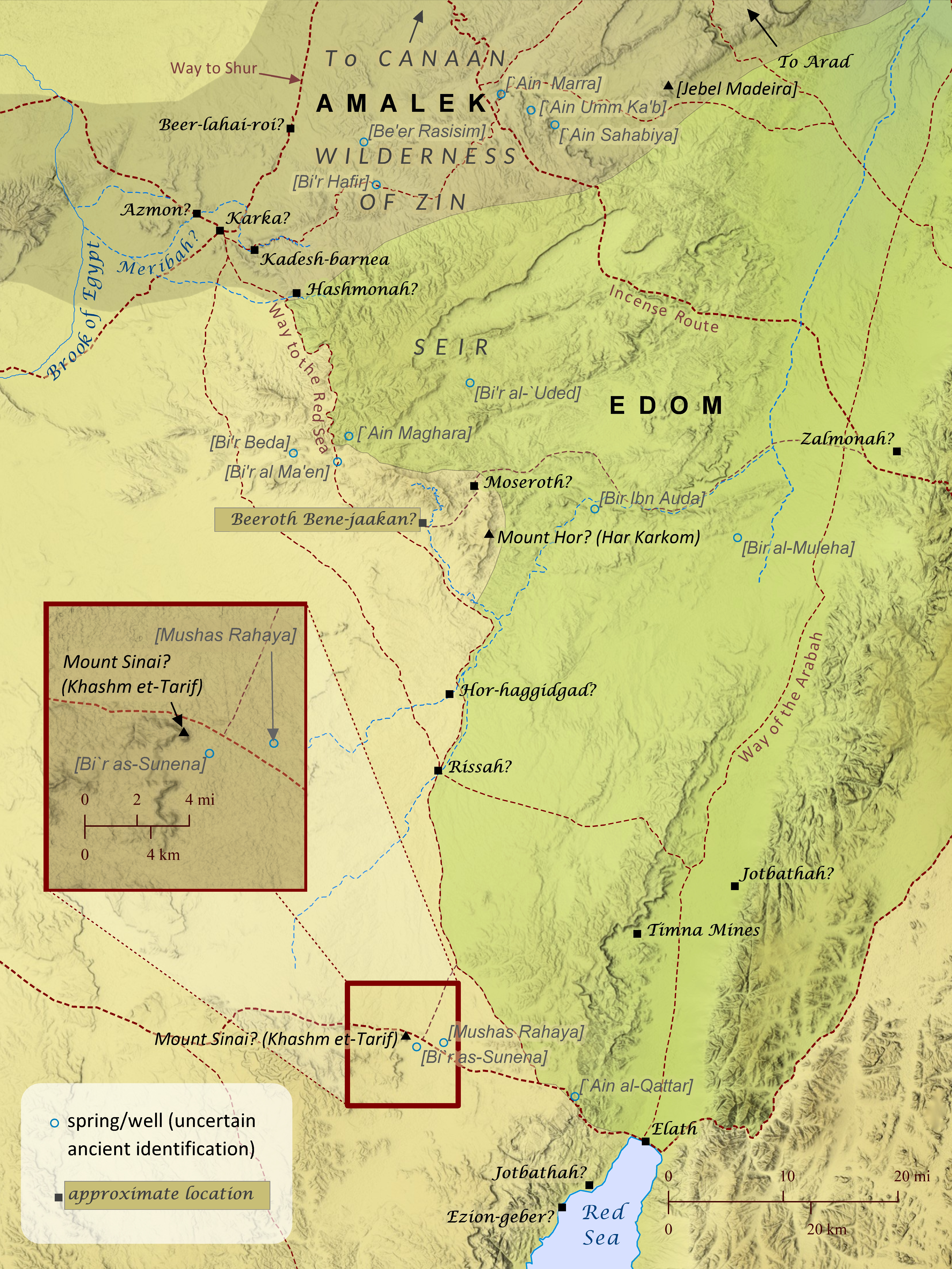
After the Israelites received the law on Mount Sinai, which may have been located at Khashm et-Tarif (see also “The Route of the Exodus”), they traveled to Kadesh-barnea, a distance that took eleven days “by the way of Mount Seir” (Deuteronomy 1:2). The phrase “by the way of Mount Seir” suggests that more than one route existed between Mount Sinai and Kadesh, as shown here, but the road the Israelites took probably ran alongside the mountainous region of Seir. This route would have offered greater access to water from wells, natural springs, and seasonal streams flowing from the hills of Seir–a critical necessity for a large group traveling through this very arid region. Nearly every location identified on this map was essentially a small community centered around one of these life-enabling sources of water. After reaching Kadesh in the wilderness of Zin, the Israelites prepared to enter Canaan by sending spies to scout out the land. But when ten of the twelve spies brought back news about the strength of the Canaanites, the people became afraid to enter the land, so the Lord punished them by condemning them to travel in the wilderness for forty years until that generation died off. Some Israelites repented and tried to enter the land, but they were beaten back to Hormah by the Amalekites and Canaanites. So for forty years the Israelites traveled from place to place, probably in the general area of Kadesh-barnea, though very few locations mentioned are able to be established with much certainty. As the forty years of traveling drew to a close, the Israelites prepared again to travel to Canaan by requesting permission from the king of Edom to pass through his land. When the king refused, the Israelites “turned away” from the Edomites and set out from Kadesh to travel to Mount Hor. The Jewish historian Josephus located Mount Hor at Jebel Nebi Harun, a very tall mountain in eastern Edom, but this has been rejected by many scholars in favor of other sites such as Jebel Madeira to the northeast of Kadesh. This author is convinced, however, that any candidate for Mount Hor must be sought to the south of Kadesh-barnea. Numbers 33:30 and Deuteronomy 10:6 mention that, during their wilderness travels, the Israelites camped at Moseroth/Moserah, which was apparently located at Mount Hor, since both Moseroth/Moserah and Mount Hor are cited as the place where Aaron died (Numbers 21:29-29; 33:37-39; Deuteronomy 10:6-9). It is difficult to envision the Israelites traveling back to the edge of Canaan after suffering defeat there the last time they attempted to enter the land. These same passages also note that after their stay at Moseroth/Moserah the Israelites traveled to Hor-haggidgad/Gudgodah (probably located along the Wadi Khadakhid) and then to Jotbathah, with no mention of passing through Kadesh, which they would have had to do if Mount Hor was north of Kadesh (since they were avoiding the land of Edom). Also, in Deuteronomy 2:1 Moses says that after the Israelites left Kadesh, “we journeyed back into the wilderness, in the direction of the Red Sea, as the Lord had told me and skirted Mount Seir for many days,” and Aaron’s death on Mount Hor fits best during this time. Similarly, Numbers 21:4 says “from Mount Hor they set out by the way to the Red Sea, to go around the land of Edom,” but there would have been no way to the Red Sea around the land of Edom if Mount Hor were located northeast of Kadesh. One element of the wilderness narratives that appears to favor a northeast location for Mount Hor, however, is the story of the king of Arad, which the book of Numbers (chapters 21 and 33) places immediately after the death of Aaron on Mount Hor. At first glance, the narrative seems to imply that the king attacked the Israelites at Mount Hor, which fits better with a northern location. Yet, it is also possible that the story is simply noting that it was after the Israelites’ arrival at Mount Hor that the king of Arad first learned of the Israelites’ renewed intentions to enter Canaan, perhaps as a result of their request to pass through Edom. But it may have been later that the king of Arad actually engaged them in battle, perhaps as they were passing north of Zalmonah and appeared to be ready to enter Canaan by way of Arad (see Numbers 33:41-42 and the map “The Journey to Abel-shittim”). For these reasons, this author believes that Har Karkom is the best candidate for the location of Mount Hor. The site is appropriately located at the edge of Seir and along the way to the Red Sea. This site’s role as an ancient cultic center is also well established. Perhaps Aaron’s priestly duties and authority in Israel had grown out of a similar role he had previously held at Mount Hor (see also Numbers 12:1-2; Deuteronomy 33:2; Judges 5:4-5), where he was eventually buried.
Open Bible Data site copyright © 2023–2026 Freely-Given.org.
Python source code for creating these static pages is available on GitHub under an open licence.
For Bible data copyrights, see the details for each displayed Bible version.
![]() The Open English Translation (OET) main site is at OpenEnglishTranslation.Bible or OET.Bible.
The Open English Translation (OET) main site is at OpenEnglishTranslation.Bible or OET.Bible.